Active Vocabulary
Date: 2015-10-07; view: 714.
Unit 3. Computer Assisted Exploration
С. Discussion
Topics:
1. Two principle seismic methods: refraction and reflection.
2. Stratigraphic exploration: various kinds of logs and their aims.
3. Maps enabling petroleum explorers to locate oil and gas.
| 1. | modeling | построение модели, моделирование |
| 2. | logging | геофизические исследования в скважинах, каротаж, регистрация (результатов испытаний) |
| 3. | visualization | придание зрительной формы |
| 4. | commitment | обязательство, затраты |
| 5. | accomplishments | достижения |
| 6. | instrumentation | контрольно-измерительные приборы |
| 8. | downtime | время вынужденного простоя |
| 9. | ||
| 10. | field-development | разработка месторождения |
| 11. | deconvolution | деконволюция, обратная фильтпация |
| 12. | coherent | связный, последовательный |
| 13. | prolonged | длительный |
| 14. | cost-effective | рентабельный |
| 15. | tremendously | очень, крайне, чрезвычайно |
| 16. | to highlight | выделять, выдвигать на первый план |
| 17. | to manipulate | зд. обрабатывать |
| 18. | to assemble | составлять, собирать |
| 19. | to utilize | использовать |
| 21. | to justify | оправдывать, подтверждать |
| 22. | to feed | зд.подавать |
| 23. | to amalgamate | объединять |
| 24. | to condense | сжимать, уменьшать в объеме |
| 25. | to reduce uncertainties | уменьшить неопределенность |
| 26. | to tune | настраивать, регулировать |
| 27. | to accelerate | ускорять |
| 28. | seismic imaging | сейсморазведочное построение |
| 29. | two-dimensional picture | двумерное изображение |
| 30. | field data | промысловые данные |
| 31. | production information | производственная информация |
| 34. | a significant probability | значительная вероятность |
| 35. | recovery rate | коэффициент нефтеотдачи, величина нефтеотдачи |
| 36. | logical progression | логическая последовательность |
| 37. | sequence of data | ряд данных |
| 38. | depletion rate | скорость истощения (месторождения) |
| 39. | seismic readings | сейсмические показания |
| 40. | velocity filtering | скоростная фильтрация |
| 41. | accompanying improvements | сопроводительные усовершенствования |
| 42. | levels of magnitude | уровни магнитуды |
| 43. | enhanced-oil-recovery strategies | усовершенствованные стратегии добычи нефти |
| 44. | streamer per swath | сейсмическая коса на полосу |
| 45. | time-lapse | цейтраферный (относится к киноизображению, когда медленное движение, например, изображение раскрывающегося бутона цветка, как-будто ускоряется) |
| 46. | productive life | срок рентабельной эксплуатации |
| 47. | bypassed oil and gas | запасы нефти и газа (разбуренные, но не извлеченные) |
| prior to | до, перед | |
| in some estimates | по некоторым оценкам | |
| in conjunction | в соединении |
One of the greatest innovations in the history of oil and natural gas exploration is the use of computers to assemble vast amounts of geologic data into a coherent "map" of the underground. This technology is referred to as computer assisted exploration, or CAEX.
Data used in CAEX is obtained from logging, from production information, and from gravimetric tests. The data is then manipulated to create a visualization of underground formations.
There are three main types of computer assisted exploration models: two-dimensional (2-D), 3-D and, most recently, 4-D. These imaging techniques rely mainly on seismic data acquired in the field and are becoming increasingly sophisticated. 3-D seismic imaging utilizes field data to generate three-dimensional pictures of underground formations, allowing scientists and engineers to better understand the composition of the earth's crust in a particular area. This is tremendously useful in oil and natural gas exploration and has increased the success rate of exploration by, in some estimates, 50 percent or better.
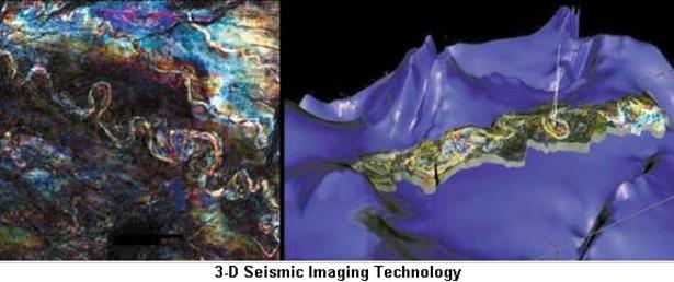
Although this technology is very useful, it is also very costly because 3-D imaging requires data to be collected from thousands of locations. As such, 3-D is a much more involved and prolonged process, and is usually used in conjunction with other exploration techniques. For example, a geophysicist may use less costly 2-D modeling to identify geologic features with a significant probability for containing oil and natural gas deposits. 3-D imaging may then be employed in those areas of highest probability.
In addition to broadly locating oil and gas reservoirs, 3-D allows for more accurate placement of wells. This increases the productivity of successful wells, allowing for more oil and natural gas to be extracted from the ground. In fact, 3-D can increase the recovery rates of productive wells to 40-50 percent, as opposed to 25-30 percent with traditional 2-D exploration techniques.
2-D Seismic Imaging
Two-dimensional computer assisted exploration includes generating an image of subsurface geology much in the same manner as in normal 2-D data interpretation. However, with the aid of advanced computer technology, it is possible to generate much more detailed maps more quickly than the traditional method. In addition, with 2-D CAEX it is possible to use color graphic displays generated by a computer to highlight geologic features that may not be apparent using traditional methods.
While 2-D seismic imaging is less complicated and less detailed than 3-D imaging, it must be noted that 3-D imaging techniques were developed prior to 2-D techniques. Thus, although it does not appear to be the logical progression of techniques, the simpler 2-D imaging techniques were actually an extension of 3-D techniques, not the other way around. Because it is simpler, 2-D imaging is much cheaper, and more easily and quickly performed, than 3-D imaging. Because of this, 2-D imaging may be used in areas that are somewhat likely to contain oil and natural gas deposits, but not likely enough to justify the full cost and time commitment required by 3-D imaging.
4-D Seismic Imaging
This type of imaging is an extension of 3-D imaging technology. However, in 4-D, various seismic readings of a particular area are taken at different times, and this sequence of data is fed into a powerful computer. The different images are amalgamated to create a "movie" of what is going on underground over time. By studying how seismic images change over time, geologists can gain a better understanding of many properties of the rock, including underground fluid flow, viscosity, temperature and saturation. While 4-D imaging is very important in the exploration process, it can also be used to evaluate the properties of a reservoir, including the depletion rate once extraction has begun.
| <== previous lecture | | | next lecture ==> |
| Залежей нефти и газа | | | B. Vocabulary Practice |